Skip to content
STV
  • Our Work
    • MarketsThe infrastructure that powers our lives.
    • ServicesWe work harder so our solutions work better.
    • Infrastructure ReimaginedHow STV is shaping the future.
    • PortfolioProjects that are making communities better.
    • Infrastructure is economic development.

      Infrastructure is economic development.

      It helps create a better quality of life and more opportunities for communities.

  • About Us
    • How We WorkWe understand. We serve. We collaborate.
    • Where We Are60+ offices across North America.
    • What We BelieveMaking communities better with integrity, partnership and optimism.
    • How We Got HereGenerational impact for over a century.
    • We’re here to improve communities.

      We’re here to improve communities.

      Our sense of purpose drives us.

  • Careers
    • Make a Positive Impact on Your Local CommunityJoin us to create the future you want.
    • Life at STVWe are a team.
    • Job ListingsFind the right opportunity for you.
    • Forget the career ladder.

      Forget the career ladder.

      At STV, your career path grows around you.

  • Insights
    • Thought LeadershipFirst-person perspectives and reflections from our team.
    • Industry ExpertiseDeep dives for projects that makes communities better.
    • Project ExcellenceHow our work is shaping the trends moving the industry.
    • We have an eye on the future.

      We have an eye on the future.

      Learn what's next in the industry.

  • News & Events
    • NewsRead our timely news and latest stories.
    • EventsConnect with us at industry events in your community.
    • We're on the move.

      We're on the move.

      See what's happening at STV.

  • Contact Us

Perspectives

How LiDAR Changes the Way We Survey Projects

Published

December 20, 2023

How LiDAR Changes the Way We Survey Projects
LiDAR equipment

From the earliest land measurements to the more precise methods that helped lay the foundations of modern cities, surveying is a crucial element of the iconic infrastructure we use every day. More recently, the surveying field witnessed a remarkable transformation with the introduction of LiDAR (Light Detection and Ranging) technology.

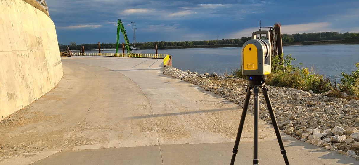
LiDAR is a revolutionary technology that harnesses laser scanning systems to craft highly precise 3-D maps. By using LiDAR, we can swiftly and efficiently map entire systems, a remarkable departure from relying on outdated drawings for modeling.

As the production manager of LiDAR & scanning services at AEI, an STV Company, I can attest to one of LiDAR’s standout advantages: its unparalleled positional accuracy. This technology can pinpoint the precise location of data collection and provide intricate details about data point relationships, enabling us to map entire cities with millimeter-level precision.

Recently, our team showcased the power of LiDAR in a project supporting a shipping company. This initiative aimed at implementing a materials handling system for the company’s fourth-largest distribution center. Using LiDAR, we identified 30 conflicts and discrepancies absent from the original designs, saving the client from costly construction errors.

Moreover, LiDAR scans allow us to collect data safely and without disrupting on-site clients or workflow. I’ve personally employed LiDAR to scan a wide range of environments, from rivers to crawl spaces, providing clients with the essential data to make well-informed decisions.

For instance, during a utility scan of a military base in need of utility rerouting solutions, my team used LiDAR to layer millions of data points on top of each scan, greatly enhancing project efficiency and precision without significant disruptions to those on site.

As our clients increasingly require higher precision and efficiency, the introduction of LiDAR expertise is poised to create new opportunities for both existing and potential clients.

We’ve only just scratched the surface of what LiDAR can do. Better tools lead to better projects, and with each project, we discover new ways to reimagine and leverage this cutting-edge technology.

LiDAR equipment

Thought Leader

Danny Stover
Danny StoverProduction Manager, LiDAR & Scanning services
design technology

Featured

Related News & Insights

Press Releases

STV Group, Inc., Acquires American Engineers, Inc., a Civil Engineering Firm with a Strong Presence in Growing Georgia, Tennessee and Kentucky Markets

Perspectives

A 360- degree View: Accessibility and Inclusivity with 3-D Mapping

Man in a wheelchair approaches a curb

Future Focused

Merging Tech and Accessibility for Public Rights-of-Way Projects

  • Privacy Policy
  • STV Logo
  • Sitemap
This field is for validation purposes and should be left unchanged.

Copyright 2025 © STV Incorporated. All rights reserved.