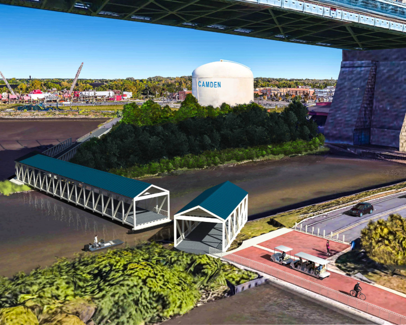
STV prepared a concept development study for the County of Camden, New Jersey, examining opportunities to extend pedestrian and bicycle access along the Delaware River waterfront. The project focused on creating a shared‑use path connecting Cooper’s Poynt Waterfront Park, located north of the Benjamin Franklin Bridge, to the existing waterfront promenade south of the bridge. The objective was to develop a consensus‑driven preliminary preferred alternative (PPA) that would improve safety, promote active transportation and strengthen connectivity between waterfront destinations while completing a critical link in the Camden GreenWay.
What challenges did STV address?
The project area presented significant environmental, regulatory and contextual challenges. The site is located within a FEMA Special Flood Hazard Area and a New Jersey Department of Environmental Protection wetlands mitigation area. In addition, the corridor falls within the limits of the National Register‑eligible Benjamin Franklin Bridge and near several designated historic districts, requiring careful coordination to balance mobility improvements with environmental protection and historic preservation.
What solutions did STV deliver?
Following the New Jersey Department of Transportation concept development process, STV evaluated multiple Complete Streets–based alternatives, including pedestrian and bicycle access via the street network and a pedestrian bridge option. The team gathered and analyzed extensive new and existing data, including topographic mapping, traffic studies, development plans, utility mapping, environmental documentation and neighborhood plans. Three primary alternatives, multiple variations and a no‑build scenario were developed and assessed, resulting in the identification of a direct‑connect swing bridge as the PPA.
How does this project benefit the community?
The study advances safe, continuous waterfront access, supports walking and bicycling and enhances regional trail connectivity along the Delaware River, improving access to public spaces and recreational amenities for Camden residents and visitors.
Key stats and accolades
- Completes a critical gap in the Camden GreenWay, supporting continuous access along a 128‑mile regional bicycle and pedestrian trail network.
- A direct‑connect pedestrian swing bridge identified through a consensus‑driven planning process.
- Consensus‑focused concept development, evaluating multiple build and no‑build scenarios to align transportation, environmental and community priorities.
- Complex regulatory setting, including flood hazard, wetlands mitigation and historic resource considerations.
- Multidisciplinary, data‑driven analysis incorporating transportation, environmental, planning and engineering inputs.